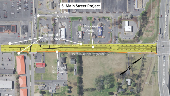
The project will include adding a three-foot-wide concrete median on South Main Street from just south of Mosby Road to Stone Spring Road/Erickson Avenue. To reduce crashes and improve traveler safety along the corridor, the project will replace the current two-way left turn lane with dedicated left turn lanes for East Mosby Road, Dukes Plaza, and Erickson Avenue. Additionally, the project includes a 5-foot-wide sidewalk on the east side of the road and shelters at three bus stops to improve multimodal access on the corridor. Existing bike lanes will be removed to accommodate the median. The project was recommended by a VDOT STARS Study completed in 2020. VDOT STARS Study ![]() [15MB] Project funded through the VDOT SMART SCALE program.
[15MB] Project funded through the VDOT SMART SCALE program.
Public Hearing (Open-house style)
The City of Harrisonburg Public Works Department held a public hearing on February 22, 2024 from 4:00pm – 6:00pm at the Sentara RMH Wellness Center, 2500 Wellness Drive, Harrisonburg.
Public Hearing Visual Aids
Corridor Crash Data Mosby to Stone Spring ![]() [1,889KB]
[1,889KB]
Installation of Medians ![]() [314KB]
[314KB]
Typical Section Graphic ![]() [266KB]
[266KB]
Overall Graphic ![]() [266KB]
[266KB]
Public Hearing Invitation Letter
English ![]() [184KB]
[184KB]
Spanish ![]() [129KB]
[129KB]
Arabic ![]() [266KB]
[266KB]
Kurdish ![]() [250KB]
[250KB]
Frequently Asked Questions & Community Feedback
Upon reviewing responses from the South Main Street Project Questionnaire (Mosby Road to Stone Spring Road/Erickson Avenue corridor) and communicating with property owners and travelers along the corridor, staff has adjusted the Mosby intersection to include 4 crosswalks, making crossing accessible in all directions. Adjustments are also being made to the number of bus shelters added with the project. The Project will continue to allow all turning movements at the Dukes Plaza entrance, as a way to balance the need for access to businesses with the safety benefits of reducing the number of entrances that have full access.
- Why are the bike lanes being removed? Existing bike lanes do not meet current standards for safety and the community has shared they feel unsafe biking along this corridor. Constructing wider bike lanes would involve significant impact to adjacent properties and utilities and would be costly. The existing bike lanes will be removed to allow for installation of a median to enhance safety of travelers on the corridor. The sidewalks will be an option for bicyclists to utilize after the bike lanes are removed. If funded, extension of the Bluestone Trail will create an alternate route for people biking to Rocktown High School and other destinations along South Main Street. Staff is attempting to secure competitive grant funding to construct this extension of the Bluestone Trail.
- How will these changes affect transportation to Rocktown High School? Changes have been planned with extensive study and evaluation of crash data and traffic volume projections. Planned changes will make the corridor safer by creating a situation with less conflicts for the increased traffic.
- How will I enter the businesses along South Main Street in this corridor when traveling North? Travelers may turn onto Mosby Road and turn into Dukes Plaza on the access road behind the businesses, turn left into the median break at the Dukes Plaza entrance/exit, or make a U-turn at Erickson Avenue.
- How will I travel North after visiting a business along this corridor? Travelers may exit onto South Main Street and make a U-turn at Mosby Road, or use the access roads behind businesses along South Main and Mosby to turn onto Mosby Road and travel to the intersection. Using the access entrance to Duke’s Plaza that is further west on Mosby Road (further form the traffic signal) will likely be easier and safer at peak traffic hours when the queue length at the signal will be longer. Exiting left out of the median break at the Dukes Plaza entrance/exit on S. Main Street is also an option, although it may be difficult to accomplish safely during peak traffic hours when finding a gap through traffic in the north and southbound directions at the same time is likely to be difficult, and sight lines may be obstructed by the northbound left turn queue.
- What happens when Interstate 81 shuts down and the corridor becomes congested? The safety benefits of this project are particularly important when there is additional traffic on the corridor, such as when there is traffic diverted from I-81. Reducing the number of locations where vehicles are taking a left turn into busy traffic helps to ensure safe traffic flow.
- How do these types of changes affect businesses along the corridor? The public input process did not produce specific concerns regarding reduced competitive advantage as a result of the changes proposed. Staff assumes this is because the changes do not decrease convenience of access to businesses enough to influence drivers to substitute a previously preferred destination in the corridor with one elsewhere. On the contrary, the reduced risk of crashes may offset or increase business competition in the corridor.
- Why is there no grass buffer for the new sidewalk? To provide a grass buffer, there would be notable impact to utility poles and steeply graded adjacent property. For this sidewalk retrofit, the cost to achieve the grass buffer isn’t warranted. If a development proposal(s) involving these properties were to hypothetically emerge, the City would work with the developer to further improve the sidewalk.
- How will you address congestion on Mosby Road? Staff has secured funds for a study for the area including the Erickson Avenue and Pear Street corridors. In the upcoming year, this study will identify potential projects to improve traffic operations and safety along these corridors that will be incorporated into the City’s Capital Improvements Program and/or Comprehensive Plan.
Please Note: Phase II of the South Main Improvement Project (Exit 243 Interchange to Mosby Road) is a separate project (view Project Webpage) with public outreach anticipated to take place in 2025 and expected construction in 2027/28. Additional improvements may also be funded along this corridor, aligned with the study that was completed in 2022 (view Study Webpage).
Project Schedule:
Preliminary Engineering – 2022-23
Right-of-way acquisition and utility relocation – 2023-24
Construction – 2025