The following projects are primarily transportation-related, but may also serve recreation, economic development, stormwater management, and/or other needs. These projects may be in different stages of development such as planning, design, right-of-way, and construction and are subject to budget appropriations. The scheduled completion dates are tentative. Information about the plans and studies that guide project selection and implementation is available on the Transportation Studies and Plans webpage.
Unless otherwise noted, questions can be directed to Public Works staff at 540-434-5928 or PublicWorks@HarrisonburgVa.gov
Funded Projects:
Construction in 2025
- East Market Street Improvements at I-81, Exit 247 (VDOT)
Multiple improvements are funded for the East Market Street corridor between Martin Luther King Jr. Way and Burgess Rd/Linda Lane, including upgrades to the I-81 interchange (exit 247). For more information visit the project webpage.
Construction in 2026
- University Boulevard Realignment
The project realigns University Blvd between the old convocation center parking lot and Forest Hill Road at the Oak Hill Drive intersection. The project replaces the existing University Blvd with a new 2-lane roadway with a shared-use path and sidewalk. The project will transition University Blvd into a safer and more efficient multi-modal corridor for travel to and from JMU and destinations in the Southeast part of Harrisonburg. It is currently a 2-lane rural typical section that has been adapted in various ways over the years as traffic volumes have grown. The project will reestablish University Blvd as an urban collector, in keeping with its current role, traffic volumes, and continuous trend of adjacent urbanization. The realignment will allow University Blvd to become the through movement at Oak Hill Drive, transferring the stop control to the side street, which will improve safety and operations for University Blvd, as well as Port Republic Road. The shared-use path will be constructed along Forest Hill Road and University Blvd between Port Republic Road and Carrier Drive, creating a continuous bicycle and pedestrian connection between the existing infrastructure on Port Republic Rd, Driver Drive, and Carrier Dr. Project funded through the VDOT Revenue Sharing Program.
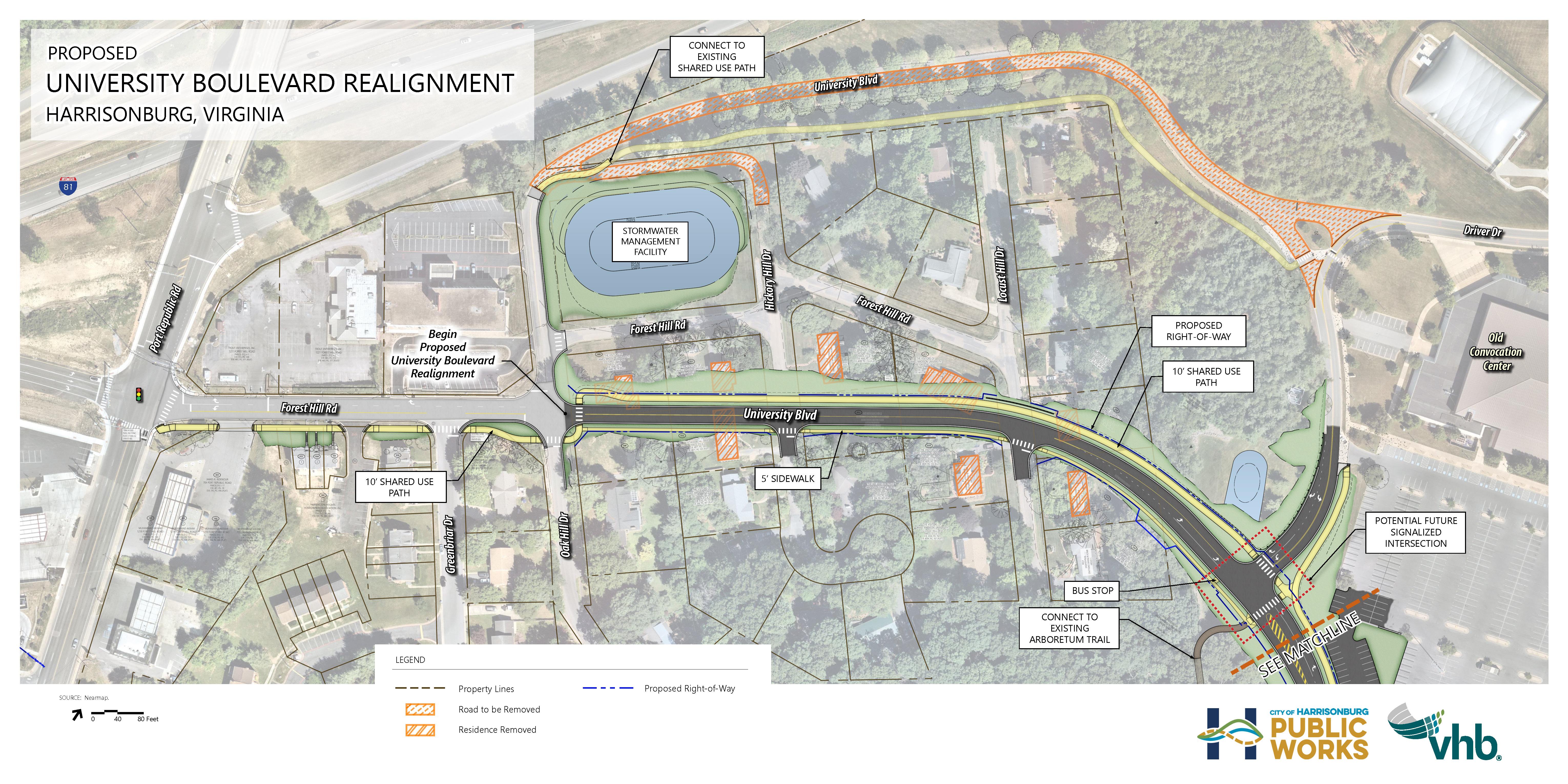
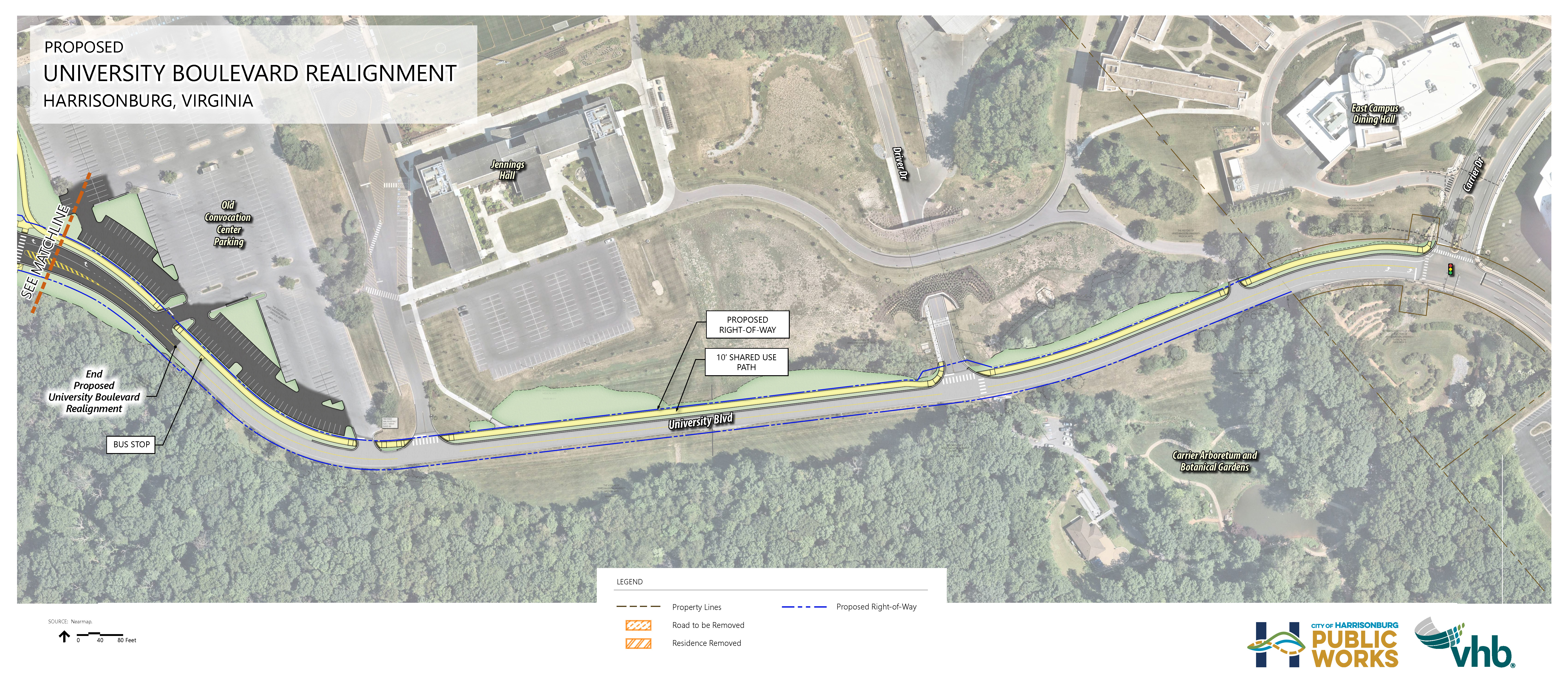
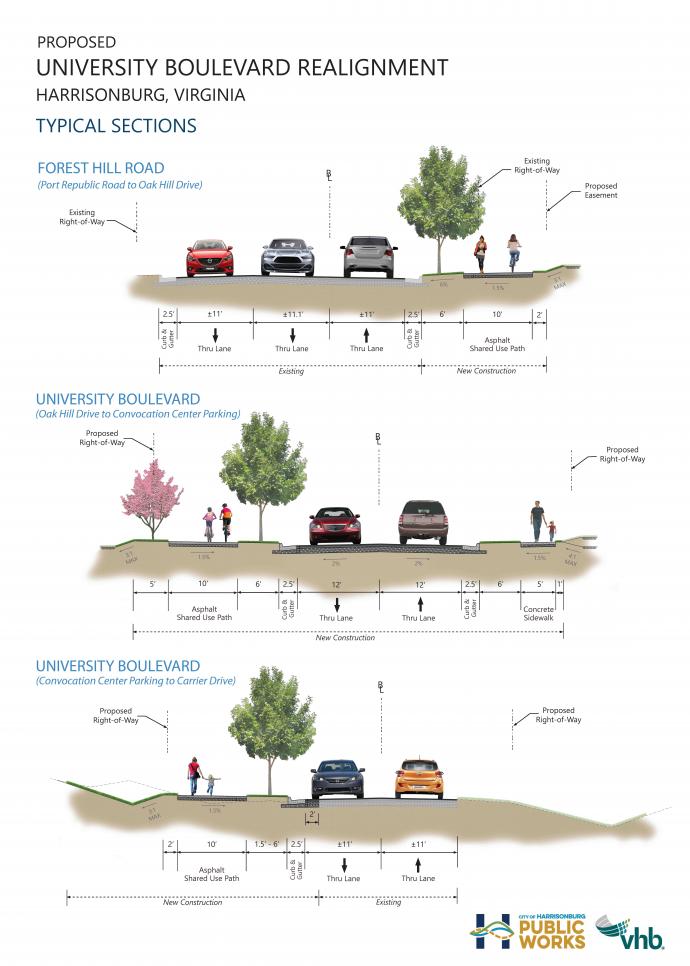
University Boulevard Realignment Project Video
Project Schedule:
Preliminary Engineering: 2021 - 2022
Right-of-way Acquisition: 2022 - 2024
Construction: 2026 - 2027
- Northend Greenway Brookside Phase
Northend Greenway Brookside Phase project plans include constructing a 10-foot-wide asphalt path between Roberts Court and the existing path at Jefferson Street, with a connection to Drake Lane. This path will create a safer and more continuous route for people walking and biking in this neighborhood and add to the overall 2.5 mile Northend Greenway Project. The project is funded through the VDOT Transportation Alternatives Program.
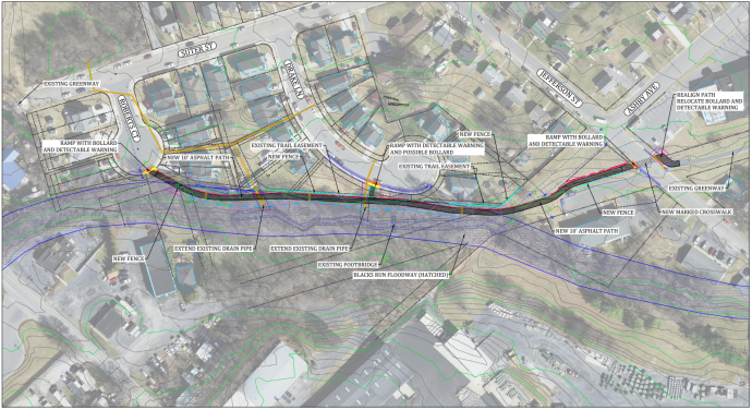
Northend Greenway Brookside Phase Open House Exhibit [13MB]
Northend Greenway Brookside Phase Open House - March 19
The Harrisonburg Public Works Department hosted an open house style public hearing on March 19, 2025 from 4:00pm - 6:00pm at Room 11 of Harrisonburg City Hall, 409 South Main Street, Harrisonburg, to discuss the effort. Visual aids and staff were present at the open house for information.
Project Schedule:
Preliminary Engineering: 2023 - 2024
Right-of-way Acquisition: 2025
Construction: 2026
- North Main Street Sidewalk
The project will construct sidewalk on both sides of North Main Street from Charles Street to Vine Street, to fill gaps between existing sidewalks. The road will be widened to create bike lanes between Holly Hill Drive and Vine Street. Pedestrian signals, ramps, and crosswalks will be installed at the intersection with Vine Street/Mt. Clinton Pike. The project is funded through the VDOT SMART SCALE program.
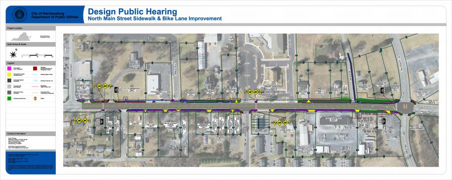
The project enhances safe pedestrian access through intersection improvements, connecting sidewalk with existing sidewalk infrastructure, and the addition of bicycle lanes. The project will create uninterrupted sidewalk from Harrisonburg’s north city limit to Downtown Harrisonburg.
Open House: The Harrisonburg Public Works department hosted an open house style public hearing on Wednesday, February 5, 2025 at the Lucy F. Simms Continuing Education Center. This was an open-house style public hearing where citizens could learn about, ask questions, and provide feedback on project plans.
Project Schedule:
Preliminary Engineering: 2022 - 2026
Right-of-way acquisition and utility relocation: 2025 - 2026
Construction: 2026
- Port Republic Road Improvements: Bluestone Drive and Bradley Drive
Bluestone Drive to Crawford Avenue
This project extends the eastbound Port Republic Road left turn lane at Bluestone Drive from 100' of storage for vehicles to 300'. The turn lane extension is expected to improve safety and operations at the intersection by more adequately accommodating queuing vehicles waiting to make a left turn onto Bluestone Drive into the JMU campus. This improvement was a recommendation of the Port Republic Road Safety and Operations Study completed in 2019. A 5’ wide sidewalk will be constructed on the south side of Port Republic Road between Crawford Avenue and the existing crosswalk of Port Republic Road at Bluestone Drive to provide a safe pedestrian connection between the residential neighborhood and the JMU campus. Additionally, a median will be constructed along this segment. Project funded through the VDOT SMART SCALE program.
Devon Lane to Hunters Road
This project addresses multiple safety concerns on the Port Republic Road corridor between Hunters Rd and Devon Lane, as identified in the Port Republic Road Safety and Operations Study completed in 2019. Installation of a signal at Bradley Drive, with associated left turn lanes on Port Republic Road, improves safety and decreases delays in the peak hours for those entering and exiting Bradley Drive. The addition of crosswalks and pedestrian signals at this intersection improves pedestrian safety and access along Port Republic Road. Construction of a concrete median between Devon Lane and Hunters Road improves safety by eliminating left-turn conflicts, which have led to crashes at Hunters Road and other locations along this segment of Port Republic Road. The project rebuilds the existing westbound bike lane as a separated bike lane, adjacent to the sidewalk, beginning close to Devon Lane and returning to street level at Hunters Road. The project rebuilds sidewalks, where impacted by this project. Project funded through the VDOT SMART SCALE program, with contributions from an adjacent private development.
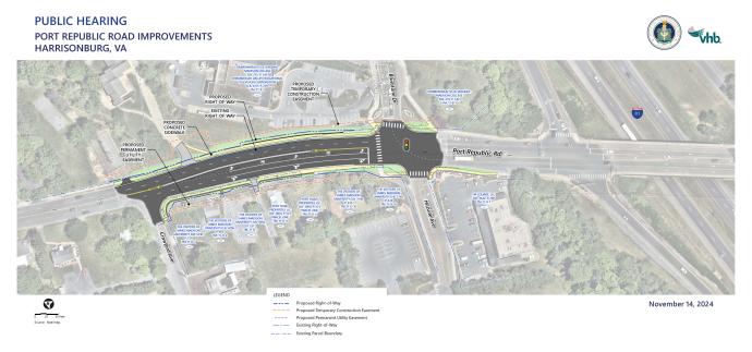
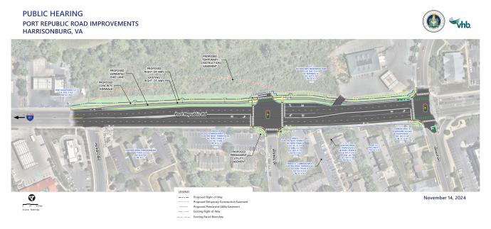
Port Republic Project Open House
The Harrisonburg Public Works Department hosted an open house on Thursday, November 14 from 4:00pm - 6:00pm at City Hall Council Chambers, 409 South Main Street, Harrisonburg. Visual aids and staff were present at the open house for information. The public was invited to ask questions and provide feedback on project design plans during the open house. The open house also included proposed improvements for the Port Republic: Devon Lane to Hunters Road project and the Port Republic: Bluestone Drive to Crawford Avenue. A questionnaire was available at the open house to collect public comments and experiences along the corridor.
Project Schedule:
Preliminary Engineering: 2023 - 2025
Right-of-way Acquisition: 2025
Construction: 2026-2027
Construction in 2027
- University Boulevard and Evelyn Byrd Roadway Reconfiguration and Sidewalks
Public Hearing - University Boulevard and Evelyn Byrd Avenue Roadway Reconfiguration and Sidewalk Project
The City of Harrisonburg Public Works department held a public hearing on Thursday, October 26, 2023 from 3:00pm - 6:00pm at the Hyatt Place Harrisonburg.
Public Hearing Visual Aids
Project Description:
This project will reconfigure University Blvd (0.7 miles) and Evelyn Byrd Avenue (1.3 miles) by converting the streets from 4 lanes to 2 vehicle lanes, a center turn lane and bike lanes to provide access management and improve safety. University Blvd has a high density of commercial entrances, which leads to dangerous weaving throughout the corridor as vehicles try to get around turning vehicles, and results in other safety hazards related to speeds and turning movements. The project will also bring a multimodal focus to University Blvd and Evelyn Byrd Ave. Sidewalks will be added to University Blvd on both sides, and on Evelyn Byrd Ave on the north/east side to connect sporadic sections of existing sidewalk. Bus shelters and benches will be added to bus stops. This project is funded by a VDOT Smart Scale grant.
Project Schedule:
Preliminary Engineering: 2022 - 2025
Right-of-way acquisition: 2025 - 2026
Construction: 2027
- Gay Street Reconfiguration and Pedestrian Improvements
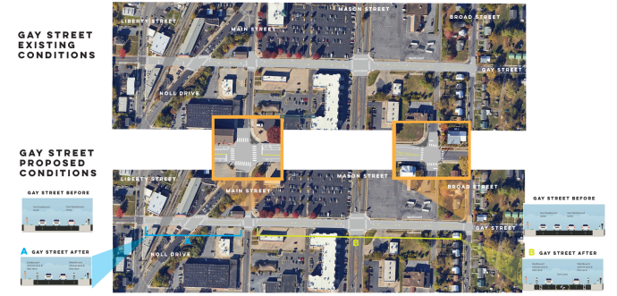
The current lane configuration of Gay Street between Broad Street and Liberty Street requires those driving or biking to change lanes at one or more locations in order to continue straight on the street. This project proposes revising the configuration to improve operations and safety for people driving, biking, and walking on this segment of Gay Street. The proposed new configuration is shown in the image below. Changes include creation of turn lanes to safely accommodate left turns, addition of bike lanes, and construction of additional crosswalks and curb ramps at Main Street and Broad Street. These improvements can be made without widening the road, to avoid impacts to adjacent properties. The concept for this project was first identified in the 2014 Downtown Streetscape Plan [488KB] and a study was completed in 2022. Funding for the project is available through the Virginia Highway Improvement Program.

Gay Street Reconfiguration Open House:
The Harrisonburg Public Works Department held an open house on April 3 from 4:00pm - 6:00pm in the auditorium of Lucy F. Simms Continuing Education Center, 620 Simms Avenue, Harrisonburg. Visual aids and staff were present at the open house for information. A questionnaire was available at the open house to collect public thoughts/suggestions and is now available digitally. Suggestions, ideas, or concerns regarding the proposed project, whether expressed at the open house or through the questionnaire, will guide the design and implementation of the project. More information about Harrisonburg roadway reconfigurations and reconfiguration projects.
Open House Visual Aids
Roadway Reconfiguration education aids are available on the Roadway Reconfiguration webpage
Project Schedule:
Preliminary Engineering: 2024 - 2026
Right-of-way Acquisition: 2026
Construction: 2027
- South Main Street: Mosby Road to Stone Spring Road
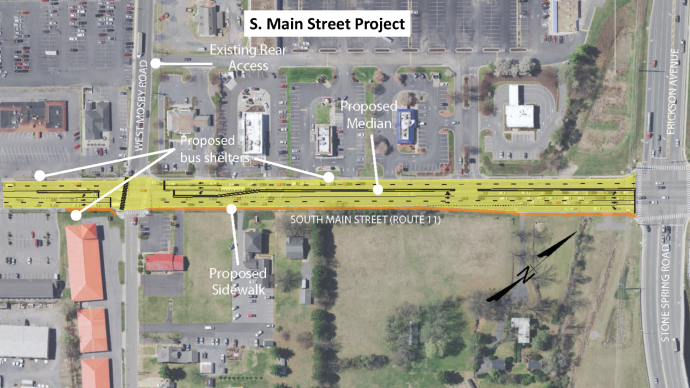
The project will include adding a three-foot-wide concrete median on South Main Street from just south of Mosby Road to Stone Spring Road/Erickson Avenue. To reduce crashes and improve traveler safety along the corridor, the project will replace the current two-way left turn lane with dedicated left turn lanes for East Mosby Road, Dukes Plaza, and Erickson Avenue. Additionally, the project includes a 5-foot-wide sidewalk on the east side of the road and shelters at three bus stops to improve multimodal access on the corridor. Existing bike lanes will be removed to accommodate the median. The project was recommended by a VDOT STARS Study completed in 2020. Project funded through the VDOT SMART SCALE program.
Public Hearing
The City of Harrisonburg Public Works Department held a public hearing on February 22, 2024 at the Sentara RMH Wellness Center, 2500 Wellness Drive, Harrisonburg.
Public Hearing Visual Aids
Typical Section Graphic [266KB]
Overall Graphic [266KB]
Frequently Asked Questions & Community Feedback
Upon reviewing responses from the South Main Street Project Questionnaire (Mosby Road to Stone Spring Road/Erickson Avenue corridor) and communicating with property owners and travelers along the corridor, staff has adjusted the Mosby intersection to include 4 crosswalks, making crossing accessible in all directions. Adjustments are also being made to the number of bus shelters added with the project. The Project will continue to allow all turning movements at the Dukes Plaza entrance, as a way to balance the need for access to businesses with the safety benefits of reducing the number of entrances that have full access.
- Why are the bike lanes being removed? Existing bike lanes do not meet current standards for safety and the community has shared they feel unsafe biking along this corridor. Constructing wider bike lanes would involve significant impact to adjacent properties and utilities and would be costly. The existing bike lanes will be removed to allow for installation of a median to enhance safety of travelers on the corridor. The sidewalks will be an option for bicyclists to utilize after the bike lanes are removed. If funded, extension of the Bluestone Trail will create an alternate route for people biking to Rocktown High School and other destinations along South Main Street. Staff is attempting to secure competitive grant funding to construct this extension of the Bluestone Trail.
- How will these changes affect transportation to Rocktown High School? Changes have been planned with extensive study and evaluation of crash data and traffic volume projections. Planned changes will make the corridor safer by creating a situation with less conflicts for the increased traffic.
- How will I enter the businesses along South Main Street in this corridor when traveling North? Travelers may turn onto Mosby Road and turn into Dukes Plaza on the access road behind the businesses, turn left into the median break at the Dukes Plaza entrance/exit, or make a U-turn at Erickson Avenue.
- How will I travel North after visiting a business along this corridor? Travelers may exit onto South Main Street and make a U-turn at Mosby Road, or use the access roads behind businesses along South Main and Mosby to turn onto Mosby Road and travel to the intersection. Using the access entrance to Duke’s Plaza that is further west on Mosby Road (further form the traffic signal) will likely be easier and safer at peak traffic hours when the queue length at the signal will be longer. Exiting left out of the median break at the Dukes Plaza entrance/exit on S. Main Street is also an option, although it may be difficult to accomplish safely during peak traffic hours when finding a gap through traffic in the north and southbound directions at the same time is likely to be difficult, and sight lines may be obstructed by the northbound left turn queue.
- What happens when Interstate 81 shuts down and the corridor becomes congested? The safety benefits of this project are particularly important when there is additional traffic on the corridor, such as when there is traffic diverted from I-81. Reducing the number of locations where vehicles are taking a left turn into busy traffic helps to ensure safe traffic flow.
- How do these types of changes affect businesses along the corridor? The public input process did not produce specific concerns regarding reduced competitive advantage as a result of the changes proposed. Staff assumes this is because the changes do not decrease convenience of access to businesses enough to influence drivers to substitute a previously preferred destination in the corridor with one elsewhere. On the contrary, the reduced risk of crashes may offset or increase business competition in the corridor.
- Why is there no grass buffer for the new sidewalk? To provide a grass buffer, there would be notable impact to utility poles and steeply graded adjacent property. For this sidewalk retrofit, the cost to achieve the grass buffer isn’t warranted. If a development proposal(s) involving these properties were to hypothetically emerge, the City would work with the developer to further improve the sidewalk.
- How will you address congestion on Mosby Road? Staff has secured funds for a study for the area including the Erickson Avenue and Pear Street corridors. In the upcoming year, this study will identify potential projects to improve traffic operations and safety along these corridors that will be incorporated into the City’s Capital Improvements Program and/or Comprehensive Plan.
Please Note: Phase II of the South Main Improvement Project (Exit 243 Interchange to Mosby Road) is a separate project (view Project Webpage) with public outreach anticipated to take place in 2025 and expected construction in 2027/28. Additional improvements may also be funded along this corridor, aligned with the study that was completed in 2022 (view Study Webpage).
Project Schedule:
Preliminary Engineering: 2022 - 2026
Right-of-way Acquisition: 2025 - 2026
Construction: 2027
- Safe Routes to School (SRTS) Sidewalks Project: Waterman ES and Keister ES
Safe Routes to School (SRTS) Sidewalks Project: Waterman ES and Keister ES
This project will construct three separate segments of new 5’ wide sidewalk to fill gaps between existing sidewalks and improve safe pedestrian access to two different schools: Waterman Elementary School and Keister Elementary School.
- The first sidewalk segment is on Gay Street at Waterman Elementary School where sidewalk will be constructed to fill a gap in the sidewalks along Gay Street and to create a safe and direct sidewalk and crosswalk to the school building.
- The second sidewalk will be constructed along the south side of 1st Street between the sidewalk on Lee Avenue and the crosswalk across Chicago Avenue.
- The third sidewalk segment is on Central Avenue at Keister Elementary School, providing continuous pedestrian infrastructure where there is a gap in the sidewalk along Central Avenue near the school’s parking lot.
A Public Hearing will be held Tuesday, December 9, 2025 at the City Council Meeting located at 409 South Main Street, Harrisonburg, where citizens may share their thoughts on the project to the City Council and City staff. This project is funded by a VDOT Transportation Alternatives Program (TAP) grant.
Public thoughts/questions may be submitted to Public Works by calling 540-434-5928.
The approved Environmental document for this project is available here.
Project Schedule:
Preliminary Engineering: 2024 - 2025
Right-of-way Acquisition: 2026
Construction: 2027
- Harrisonburg Pedestrian Crossings Improvement Project
This project will increase pedestrian safety at six city intersections. Safety improvements include high-visibility crosswalk pavement markings, curb extensions, pedestrian signal poles and push buttons (where applicable), and curb ramps with detectable warning surfaces. All locations improve pedestrian safety and access where there is clear need for better accommodation for people walking, including multiple locations where City staff have heard safety concerns.
- East Market Street (US-33) at Country Club Road - A signalized crosswalk with audible pedestrian signals will be added across East Market Street on the north leg of the intersection. There is pedestrian infrastructure on both sides of this intersection and multiple bus stops and destinations on both sides. The new crosswalk will create a safe pedestrian route for people crossing this six-lane major arterial to get to and from these destinations.
- Mount Clinton Pike at College Avenue - Curb bump-outs and associated curb and gutter will be constructed to significantly reduce the length of the existing crosswalk across Mt. Clinton Pike. Reducing the length of the crosswalk reduces the exposure of pedestrians to vehicles and narrowing the road encourages drivers to obey the 25-mph speed limit.
- North Mason Street at East Wolfe Street - Signalized crosswalks with audible pedestrian signals will be added across the north and east legs of the intersection. There is currently no crosswalk leading to the sidewalk on the northeast corner of this intersection. Given the location in downtown Harrisonburg, many pedestrians will benefit from the addition of these safe pedestrian routes.
- Broad Street at East Wolfe Street - Curb ramps will be built and three new crosswalks installed to provide safe and accessible routes for those walking in this neighborhood or walking to the nearby downtown district.
- Broad Street at Effinger Street - Curb ramps will be built and two new crosswalks installed to provide safe and accessible routes for those walking in this neighborhood or walking to the nearby downtown district.
- Old Furnace Road at Tower Street - Curbs ramps will be built and two new crosswalks installed to connect sidewalk along Old Furnace Road as well new sidewalk on Tower Street. These crosswalks are needed in creating a safe, accessible, and continuous, pedestrian route along Old Furnace Road.
Project Schedule
Preliminary Engineering: 2025 - 2026
Right of Way Acquisition: 2026 - 2027
Construction: 2027 - 2028
Construction in 2028
- South Main Street: Exit 243 Interchange to Mosby Road
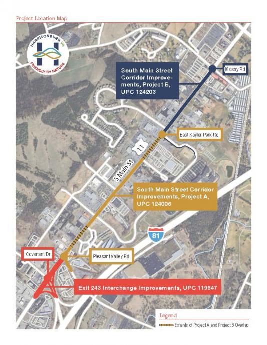 The project makes multiple improvements to South Main Street in the vicinity of the I-81 Exit 243 interchange and extending north nearly to Mosby Road.
 The project will have safety benefits and improve operations at intersections to reduce delay. Information about each aspect of the project is provided below. Project funded through the VDOT SMART SCALE program.
At the intersection of South Main Street, Covenant Drive, and the I-81 on-ramp and off-ramp (Exit 243), the improvements will construct additional turn lanes and associated changes to improve operations at this intersection. The intersection of South Main Street and Pleasant Valley Road will also be improved through construction of additional turn lanes. At the South Main Street and Pointe Drive intersection, a change will be constructed to improve safety and reduce delay through an innovative way of accommodating left turns from Point Drive.
To improve safety along South Main Street, a median will be constructed for the majority of the segment. Sidewalk will be added along the west side of South Main Street, where there isn't existing sidewalk, between the existing sidewalk south of the interchange and the existing sidewalk north of Pointe Drive. Additional short distances of sidewalk will be added on Pleasant Valley Road, the east side of South Main Street, and Kaylor Park Drive. Pedestrian signals, ramps, and crosswalks will be installed where appropriate at the intersections with Covenant Drive and with Pleasant Valley Road. An enhanced crosswalk across South Main Street will be constructed just south of Pointe Drive. Shelters will be installed at 4 bus stops on the corridor.
For information about the project to make improvements on South Main Street between Stone Spring Road and Mosby Road, view this webpage.
Project Open House
The Harrisonburg Public Works Department hosted an open house on Wednesday, March 12 from 4:00pm - 6:00pm at the Harrisonburg Public Works Administration Building, 320 East Mosby Road, Harrisonburg.
Project Questionnaire
The Project Questionnaire closed April 9.
Open House Resources:
- Open House Proposed Plans Exhibit 1 [22,435KB]
- Open House Project Location Map [6,124KB]
Project Schedule:
Preliminary Engineering: 2023 - 2026
Right-of-way Acquisition: 2026 - 2027
Construction: 2028 - 2029
- Liberty Street Project
November 2025 Press Release: Open House to Highlight Downtown Liberty Street Enhancements [265.8KB]
June 2023 Press Release: Harrisonburg to receive $14.3 million in federal funds for Liberty Street project [620KB]
Background:
In 2023, the offices of U.S. Senator Tim Kaine and U.S. Senator Mark Warner announced on June 26, 2023, that Harrisonburg would receive approximately $14.3 million in federal Rebuilding American Infrastructure with Sustainability & Equity (RAISE) grant funds to support the City’s Downtown Harrisonburg Streetscape & Mobility Transformation project. The project will create safer and more accessible routes for travelers in Downtown, enhance the area's streetscape aesthetics, and increase transportation and trail connectivity for community members and visitors, among other benefits. View the press release from the U.S. Senator’s office. The RAISE grant will fully fund the transportation components of the Liberty Street Project with local funds being contributed to the water and sewer replacements. The installation of these improvements will require the acquisition of right-of-way and/or temporary easements from properties within the project limits. Existing public and private utilities in conflict with the proposed design will be relocated as necessary.
The project was originally identified in the Harrisonburg Downtown 2040 Plan, which looked at ways to improve Harrisonburg’s Downtown for the future. Prior to the creation of this Plan, a traffic study was completed to evaluate the potential to reduce Liberty Street to 1 vehicle lane.
The Liberty Street Project (also known as the Downtown Harrisonburg Streetscape & Mobility Transformation project) includes:
- The transformation of one lane (starting at Noll Drive at Kratzer Avenue, moving south down Liberty Street to Grattan Street) into two-way separated bicycle lanes, also known as a two-way cycle track, protected by a median separating the bike lanes from traffic.
- Installation of a connecting section of 10’ foot path from Grattan Street to Martin Luther King Jr. Way, where the Bluestone Trail begins and runs through James Madison University to Purcell Park.
- Upgrades that improve safety for pedestrians throughout the corridor including curb extensions at intersections, ADA-complaint curb ramps, enhanced crosswalks, pedestrian signals, and bus stop bays with accessible boarding areas.
- Intersection enhancements such as increased landscaping, decorative signal poles, modernized traffic signals, and revised signal timings to support multimodal movements.
- Corridor-wide access management measures that will reduce conflict points by consolidating entrances and improving driveway alignments, with select entrances being closed or narrowed to enhance safety and increase pedestrian space.
- Changes to the intersection of Liberty Street, Main Street, and Grattan Street to improve safety for all users.
- Green space use (installation of grass, gardens, etc.) in various locations within the median, supporting downtown beautification and City environmental initiatives and programs.
- Replacement of aging water mains and upgrade select sanitary sewer lines.
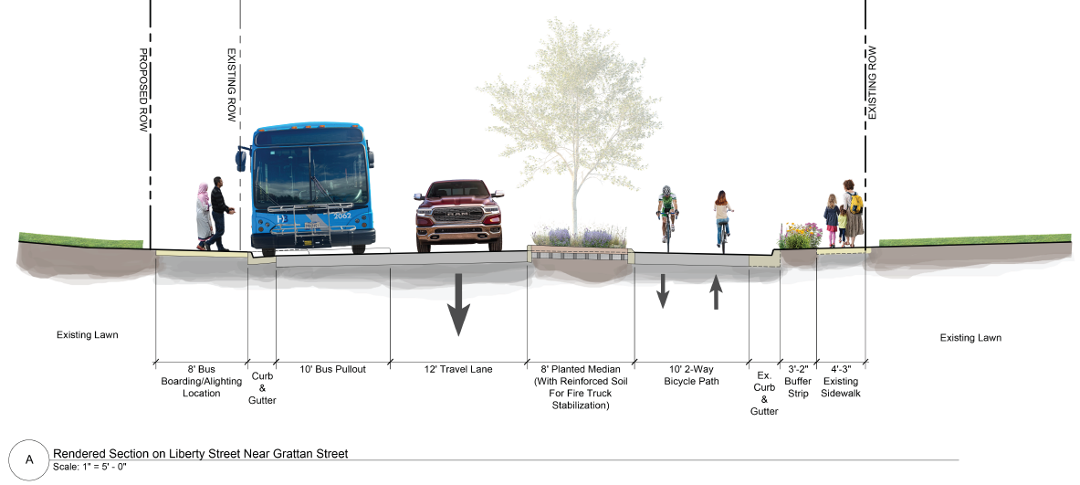
Above is a diagram from November, 2025 that shows the basic project concept. Final design plans will vary to best accomplish the two-way separated bicycle lanes and median space for each block of the project. The design of vegetation in the medians and intersection upgrades are also subject to change.
View the perspective project renderings:
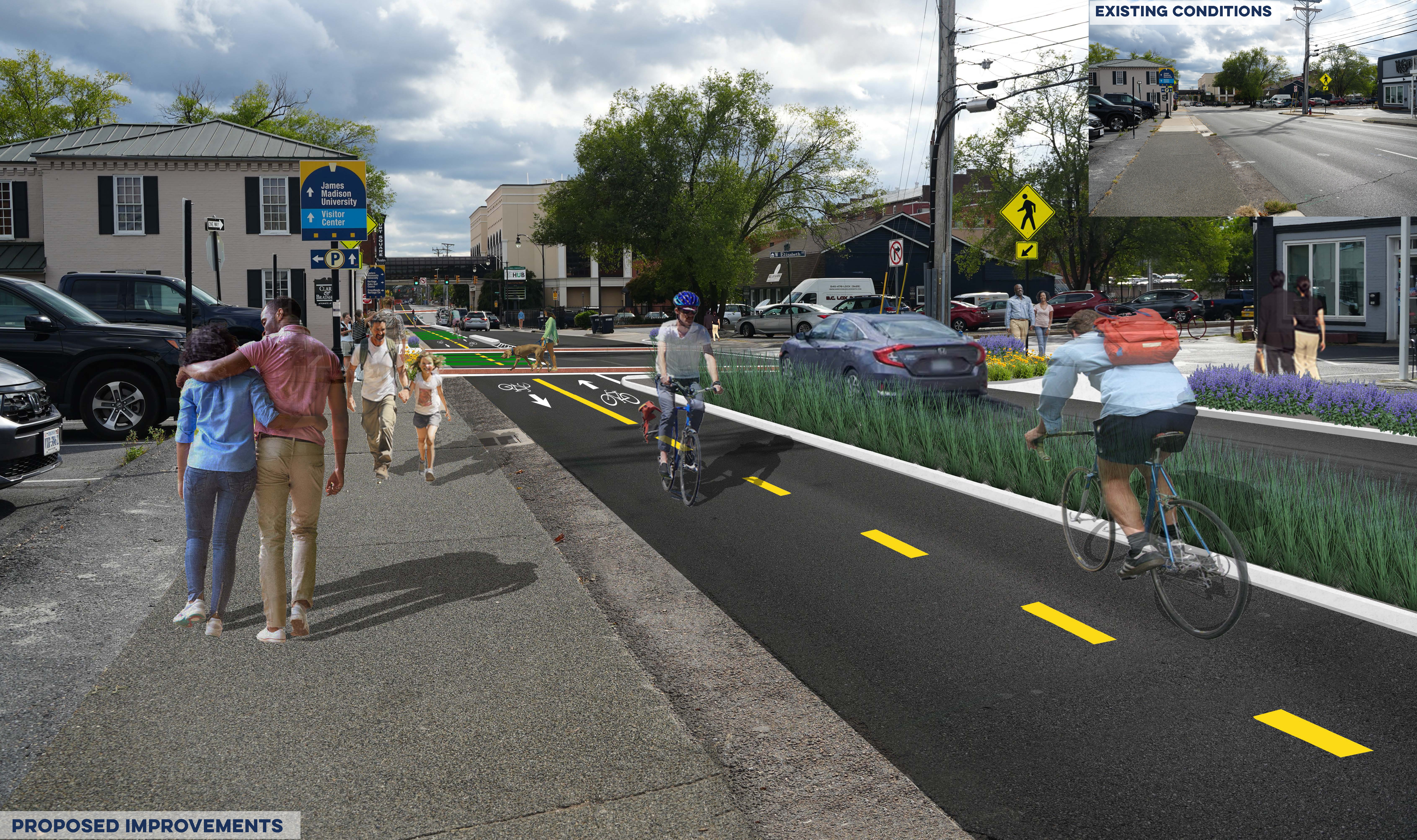
Liberty Street and West Elizabeth Street Perspective Views 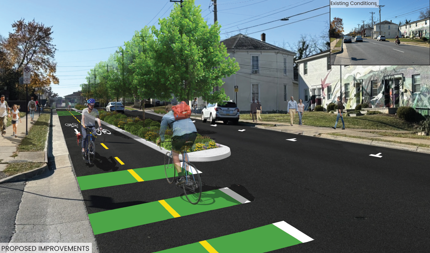
Liberty Street and Warren Street Perspective Views Additional Materials from the Kickoff Open House (12/3/25):
Open House Brochure [1.4MB]
Section Renderings [3MB]
Roll Plot Renderings [8.4MB]
Project FAQ's [66.6KB]
Project Schedule:
Preliminary Engineering: 2025 - 2026
- Kickoff Open House: December 3, 2025 from 4:30pm-6:30pm at City Hall Council Chambers
- An online feedback form was available December 3-17 to gather public comment on the proposed design.
Right-of-way Acquisition: 2026 - 2027
Construction: 2028 - 2029
Construction Dates TBD
- Pear Street & Erickson Avenue Intersection Safety Improvements
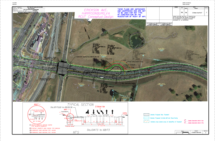
This project creates a modified Restricted Crossing U-turn (RCUT) at the intersection of Pear Street and Erickson Avenue to improve safety and operations at this intersection. 3 out of 4 left turns, as well as the through movements on the minor approaches, are redirected to signalized U-turns. Marked crosswalks will be provided at the Pear Street intersection, including a pedestrian refuge and enhanced crosswalk to cross Erickson Avenue.
Project Schedule:
Preliminary Engineering: 2026
- Reservoir Street Sidewalk: Dutch Mill Court to Harrisonburg Crossing
The project will construct approximately 1,200 feet of sidewalk on the east side of Reservoir Street from Dutch Mill Court to the Harrisonburg Crossing shopping center entrance to fill gaps in the pedestrian network. The sidewalk will be 5 foot wide with a 2 foot wide grass buffer strip between it and back of curb. The bridge over I-81 in the middle of the corridor has existing sidewalk. The project will make pedestrian improvements to the signalized intersection of Reservoir Street and the Harrisonburg Crossing shopping center entrance.
Project Schedule:
Preliminary Engineering: 2026
- Harrisonburg Safe Routes to School (SRTS) Pedestrian Crossings Improvement Project
This project will install and/or improve pedestrian crossings at eight unsignalized and midblock crossings in the City of Harrisonburg. These pedestrian crossings are all located at or near city schools, as part of the Safe Routes to School (SRTS) initiative, or at other locations where youth are known to be present. Improvements include eleven pairs of rectangular rapid flashing beacons (RRFBs), along with ADA compliant directional curb ramp improvements where appropriate.
- Washington Street near Lucy F. Simms Continuing Education Center and Ralph Sampson Park - a pair of RRFBs will be added at each of the following locations: the intersection of Washington Street and Simms Avenue, intersection of Washington Street and Commerce Drive, and the intersection of Washington Street and Northfield Court. Curb ramps will be built, along with 50 feet of new sidewalk along the east side of Northfield Court.
- South Avenue at Central Avenue – pairs of RRFBs will be added to both crosswalks across South Avenue connecting to the existing sidewalk on the east side of Central Avenue that students currently use to walk to Keister Elementary School. Each corner of the intersection will be constructed with curb ramp improvements.
- Maryland Avenue at Roosevelt Street - a pair of RRFBs, as well as curb bump outs and directional ramps, will be added to the crosswalk that connects to the existing sidewalk on Maryland Avenue that students currently use to walk to Keister Elementary School.
- Chicago Avenue at First Street - a pair of RRFBs will be added to the existing crosswalk at the intersection of Chicago Avenue and First Street, near Waterman Elementary School. This improved pedestrian crossing will connect to another project that will construct a new sidewalk along the south side of First Street into the adjacent neighborhood.
- Franklin Street at Myers Avenue - a pair of RRFBs will be added to both crosswalks across Myers Avenue connecting to the existing sidewalk that students currently use to walk to Spotswood Elementary School.
- West Market Street (US-33) east of Brickstone Court - will be installed as a two-stage crossing with a median refuge island, featuring two pairs of RRFBs, two crosswalks, and four curb ramps. This proposed crossing will provide new access to Thomas Harrison Middle School as well as Westover Park. This proposed crossing will connect the existing ten-foot sidewalk on the south side of West Market Street to a five-foot sidewalk on the north side of the roadway in an area where the nearest signalized pedestrian crossings are over 1400 feet away in either direction.
Project Schedule
Preliminary Engineering: 2026
Right of Way Acquisition: TBD
Construction: TBD
- Port Republic Road Improvements: I-81 Exit 245 and Forest Hill Road
This project will construct the following improvements in the vicinity of the Port Republic Road, Forest Hill Road, and I-81 off-ramp (Exit 245) intersection:
- On Forest Hill Road, a second left turn lane will be added resulting in the approach having one right turn lane and two left turn lanes.
- On Port Republic Road, a right turn lane will be constructed at Forest Hill Road.
- Reconstruct impacted sidewalk and add a short segment of sidewalk on the west side of Forest Hill Road.
- Install a concrete median on Port Republic Road from Forest Hill Road to Hunters Road.
- Construct a ten-foot shared use path on a parallel alignment behind two properties.
- Construct a boarding and alighting area for the bus stop on the east side of Port Republic Road.
- Install a pedestrian refuge island at the intersection with the I-81 NB on-ramp.
This project reflects the preferred alternative of the I-81 Exit 245 Project Pipeline study and is funded through the VDOT SMART SCALE program.
Project Schedule
Preliminary Engineering: 2029
Right of Way Acquisition: TBD
Construction: TBD
- Mount Clinton Pike: Acorn Drive Roundabout + Northend Greenway Railroad Crossing
This project will construct a single-lane roundabout at the Mt. Clinton Pike & Acorn Drive intersection. The roundabout will include shared use path on all sides, with appropriate crosswalks, to accommodate those walking or biking around the roundabout. New segments of sidewalk will also be constructed along the east side of Acorn Drive and north side of Mt. Clinton Pike, connecting to sidewalk built by future development and ultimately North Main Street.
In addition, a shared use path will be constructed along the south side of Mt. Clinton Pike between the existing Northend Greenway and Virginia Avenue intersection. This segment will eliminate an existing gap on the Northend Greenway and will construct a shared use path railroad crossing and bike/ped crossing improvements for all legs of the Virginia Avenue at Mt. Clinton Pike intersection, including installation of a new crosswalk and replacement of all existing curb ramps and crosswalks. This project is funded through the VDOT SMART SCALE program.
Project Schedule
Preliminary Engineering: 2029
Right of Way Acquisition: TBD
Construction: TBD
Completed Projects:
2025
- Country Club Road Sidewalk
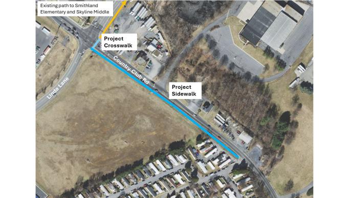
Sidewalk was constructed on the south side of Country Club Road between Linda Lane and Spotswood Homes mobile home park. A signalized crosswalk was also installed at Linda Lane to provide a safe route for walking from this neighborhood to destinations including Smithland Elementary School and Skyline Middle School. Funded through the VDOT Transportation Alternatives Program.
A Public Hearing was held Tuesday, February 27, 2024, at the City Council Meeting located at 409 South Main Street, Harrisonburg, where citizens were able to offer their thoughts on the project to the City Council and City staff.
The project added a new five-foot (5') sidewalk along the west side of Country Club Road between Spotswood Trailer Park and Linda Lane. This project was funded by a VDOT Transportation Alternatives Program (TAP) grant.
Project Schedule:
Preliminary Engineering: 2024
Construction: 2025
The new sidewalk extends from Linda Lane to the Spotswood mobile home park. The new crosswalk and pedestrian signal. - North Mason Street Complete Street Demonstration Project
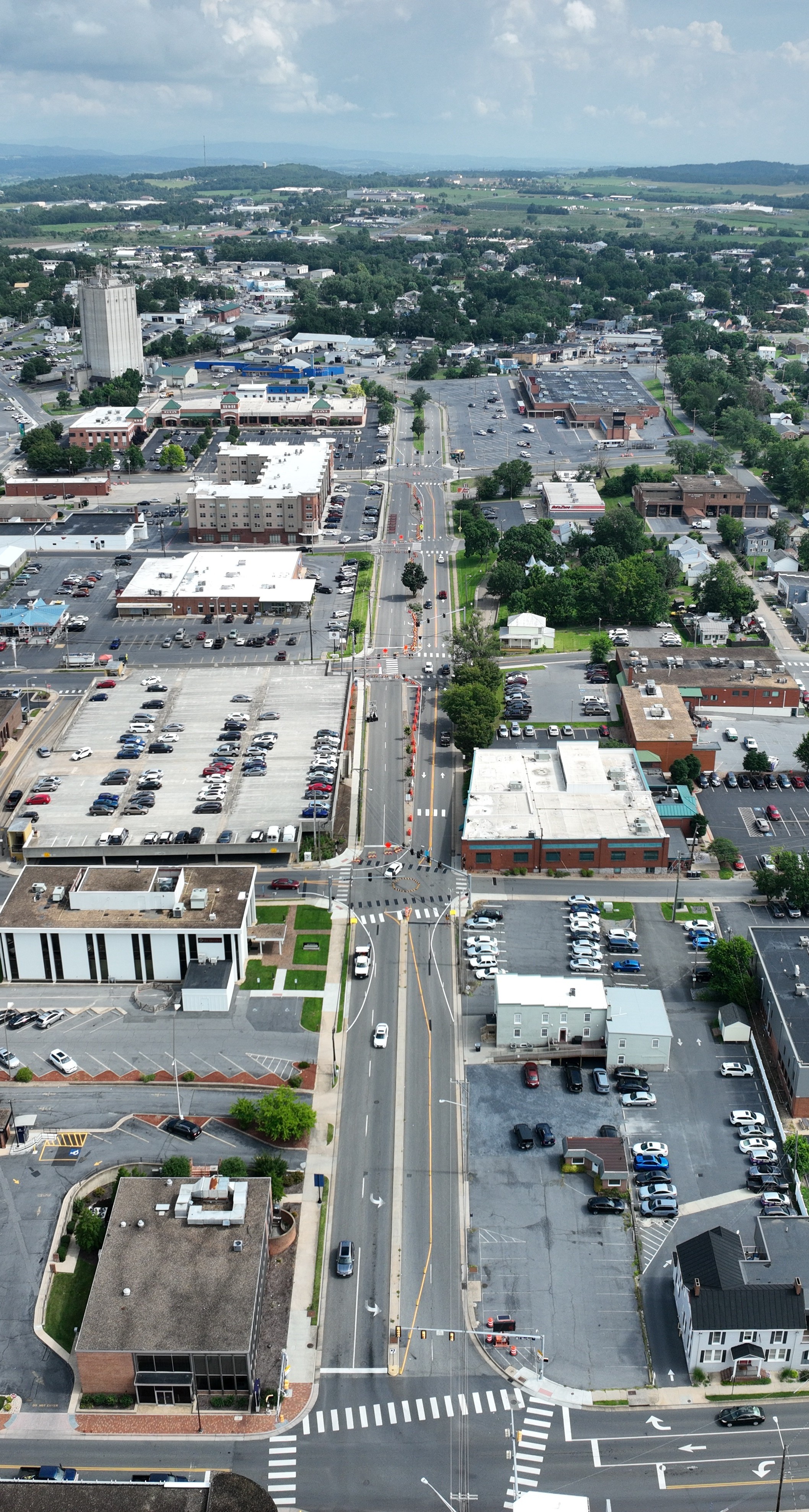 The City of Harrisonburg partnered with national nonprofit Smart Growth America to conduct a Complete Street Demonstration Project on North Mason Street, between East Elizabeth Street and East Gay Street in Downtown Harrisonburg. Smart Growth America empowers communities through technical assistance, advocacy, and thought leadership to realize a vision of livable places, healthy people, and shared prosperity.
 Take a Drone Flight down North Mason Street
What is a demonstration project?
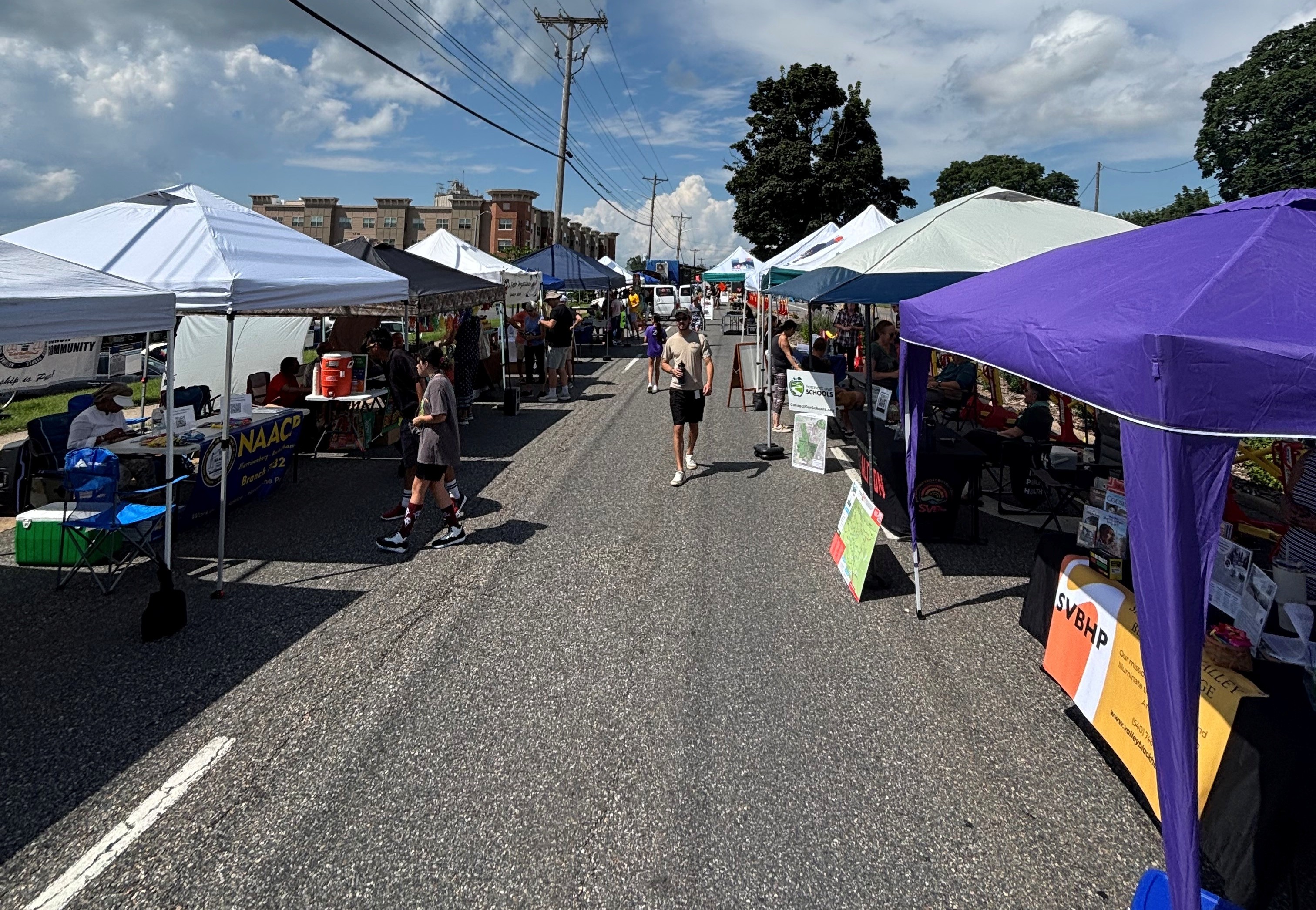
Harrisonburg Public Works made temporary changes to the configuration of North Mason Street that shifted all traffic to the two east lanes of North Mason between Gay Street and Elizabeth Street, as shown in the picture on the right. Temporary roundabouts were in place at the North Mason Street intersections with Gay Street and with Elizabeth Street. The changes were installed starting on July 7 and remained in place until August 4.
This temporary change allowed the City to test if roundabouts would be successful at those two intersections, while creating shorter crossing times of North Mason Street at multiple intersections for pedestrians and bicyclists, and opening up space currently used for vehicles (the west lanes of North Mason Street between Gay Street and Elizabeth Street) for other community use – such as space for walking and biking, areas for picnic tables, and other uses.
A community event took place along the North Mason Street corridor on Saturday, July 12, to allow the public to use that space traditionally used by vehicles. The event was held in the closed west lanes of North Mason Street between Gay Street and Elizabeth Street.
Why is this approach being utilized?
Quick-build demonstration projects like the one completed on North Mason Street have been used across the country to explore how a community might slow speeds on an existing street, create new connections, or encourage more walking and biking, as just a few examples. They give space for practitioners to test new ideas and innovative best practices. They help engage the community to gather real-time feedback on a potential design. Their low-cost temporary nature also allows communities to explore possible designs before committing to potential permanent changes to existing infrastructure. They bring numerous benefits, like:
- Improving safety overnight on corridors or intersections
- Cheaply testing out specific designs, interventions, and materials
- Engaging everyone involved throughout the process – community members, transportation staff, elected leaders
- Developing new knowledge and partnerships
- Gathering valuable feedback on designs
- Building support for a better permanent project shaped by more feedback and actual users
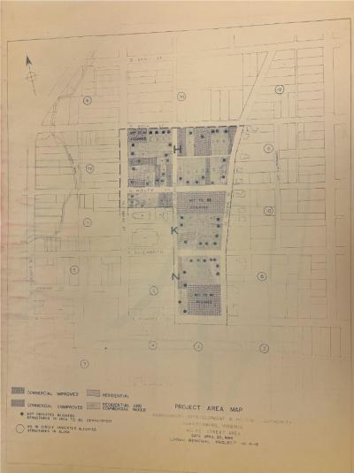
(Above) A map showing what a portion of Mason Street looked like prior to Urban Renewal and the homes and businesses that were slated for demolition to allow for Mason Street's reconfiguration. This map is included in JMU Archives. How does this effort tie into other ongoing projects?
The North Mason Street Complete Street Demonstration Project was completed in conjunction with the Harrisonburg Community Connectors Project. North Mason Street is a particular focus area for the Community Connectors Project due to its construction as part of Urban Renewal. Many homes and businesses were demolished by the City during Urban Renewal to reconfigure and widen North Mason Street into the 4-lane street it is today. The demonstration project’s goal was to be a step in the process for the City of Harrisonburg and its community members to envision a better North Mason Street that helps acknowledge and tell the story of urban renewal in this area, advance efforts to repair some of that damage, and create a place that everyone can be proud of. Some community feedback about North Mason Street was gathered during public engagement events focused on the development of the Northeast Neighborhood Small Area Plan, and this input was incorporated into the Complete Streets Demonstration Project.
Learn more about other components of the Harrisonburg Community Connectors: project, and the history of this area, at https://harrisonburgva.gov/community-connectors.
What happens now that the demonstration project is complete?
While temporary traffic adjustments were in place, City staff collected data regarding how the corridor was used by all users, in addition to seeking public feedback. We appreciate residents taking the time to share their experiences and thoughts regarding the North Mason Street Demonstration Project, as over 1500 responses were provided! All feedback has been reviewed and analyzed. The summary slides [6.9 MB] highlight key findings from the data collected and community input, as well as goals for any permanent project. A study is currently underway to evaluate and consider a permanent project. View the study webpage.
2024
- Federal Street Block II
The project constructs a shared-use path on Federal Street between East Market Street and East Water Street. It replaces the posts that currently delineate the path with more permanent features that separate the path from the vehicle lane.
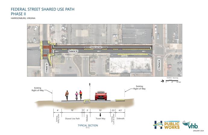
Project Schedule:
Preliminary Engineering – 2021-22
Right-of-way acquisition and utility relocation – 2023
Construction – 2024
Federal Street Block I
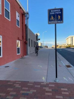
This project reallocated space on Federal Street, between Elizabeth Street and Market Street, to construct a shared-use path that people bicycling and walking can use as an alternative to Liberty Street, Main Street, and Mason Street, where there are no separate facilities for bicycles. The project made a 2-way local street in Downtown into a one-way street to provide the space for the separated bicycle and pedestrian path. The block between Elizabeth Street and Market Street has become one-way northbound for vehicle traffic. A conceptual diagram of the proposed improvements, as identified in the Downtown Streetscape Plan, is shown below. This project received funding through the VDOT Transportation Alternatives Program.
Project Schedule:
Between Elizabeth Street and Market Street
Preliminary Engineering - 2019
Construction - 2020
The Federal Street shared use path is planned to connect the Northend Greenway to the Bluestone Trail by way of downtown, to eventually provide a seamless, dedicated north/south bicycle and pedestrian route. More information can be found in the Bicycle Pedestrian Transportation and the Downtown Streetscape Plan.
- Mount Clinton Pike Road Improvement Project
The Mt. Clinton Pike Improvements Project will improve safety for people walking, jogging, biking, and driving between Virginia Avenue (Route 42) and Park Road. The project will extend the Northend Greenway by building a shared-use path along the north side of Mt. Clinton Pike. Other aspects of the project include a left turn lane on Mt. Clinton Pike for turning onto Chicago Avenue and constructions of some segments of sidewalk on the south side of Mt. Clinton Pike.
Project History
The project was initially intended to improve safety and accessibility by improving an offset intersection and adding separated bicycle and pedestrian accommodation. In 2014, the General Assembly passed House Bill 2, which restructured the way the Virginia Department of Transportation (VDOT) awards transportation funds to localities. The legislative action significantly affected the Mount Clinton Pike Road Improvement project, which was well into the design phase of development at that time. The City attempted multiple times, unsuccessfully, to obtain the remaining necessary funding to complete the project under the new funding rules. Since it is significantly unlikely that construction funding can be obtained for the larger scope of the project, staff received VDOT approval to change the scope of the project to allow the City to use the balance of the previously-awarded (pre-2014) project development funds to complete a beneficial, but smaller, project.
Project Schedule:
- Preliminary Engineering and Public Involvement - Spring 2021
- Right of Way/Utilities - 2021- 2022
- Construction - 2023/24
Related Projects:
- Chicago Avenue Corridor Study - completed in 2013, this study makes recommendations for traffic, engineering, and land use along Chicago Avenue, Mt. Clinton Pike, Park Road, and Parkwood Drive. This study is now outdated.
- Northend Greenway - Shared use path project between Park View area and Downtown Harrisonburg.
- Kaylor Park Drive Extension to Rocktown High School
The project extends East Kaylor Park Drive to the site of Rocktown High School and connects to S. Main Street south of Pointe Drive. The project will install a signal at the South Main Street and East Kaylor Park intersection and create a right-in, right-out intersection at the new connection to South Main Street. A shared-use path will be constructed along the road through the high school site, with a sidewalk or shared-use path connections to South Main Street.
Project Schedule:
Preliminary Engineering – 2021-22
Right-of-way acquisition and utility relocation – 2021-22
Construction – 2023/24
2023
- Vine Street Sidewalk - 100 Block
Sidewalk will be constructed on the south side of Vine Street between N. Main Street and Harris Garden Apartments. This will connect those who live along Vine Street to the sidewalks planned for construction along N. Main Street, Mt. Clinton Pike, and US 11 in Rockingham County. It will be a 5’ wide concrete sidewalk with a 2’ wide grass strip separating the sidewalk from the road. Funded through Community Development Block Grant (CDBG).
- Vine Street Sidewalk - 500 Block – completed in 2023
The project constructs a sidewalk on the west side of Vine Street between Washington Street and Emerson Lane. This will fill a gap between the existing sidewalk on Vine St and Washington St and the sidewalk on Emerson Ln. It will be a 5’ wide concrete sidewalk with a 2’ wide grass strip separating the sidewalk from the road. Funded through the Community Development Block Grant (CDBG) Program.
2022
- Commerce Drive Sidewalk
The project constructs a sidewalk on the south/west side of Commerce Drive to fill a gap in the sidewalk between N. Main Street and the existing sidewalk at Commerce Village. It will be a 5’ wide concrete sidewalk with a 2’ wide grass strip separating the sidewalk from the road. Funded through the Community Development Block Grant (CDBG) Program.
- Water Street Sidewalk
The project constructs a sidewalk on the north side of W. Water Street between Willow Street and Dogwood Drive. This will connect the existing Water Street sidewalk to the sidewalk on Dogwood Dr that leads to Westover Park. Funded through the Community Development Block Grant (CDBG) Program.
- Friendly City Trail Shared Use Path
The Friendly City Trail is open for use!
This shared-use path connects three schools (Harrisonburg High School, Bluestone Elementary School, and Thomas Harrison Middle School), two parks (Hillandale and Westover Parks), and several residential neighborhoods on the west side of Harrisonburg. The path is more than 2 miles from one end to the other and consists of sidewalk and shared-use path improvements that provide connectivity and recreational options to people walking, jogging, and bicycling.
The sidewalk portion of the project was constructed along the east side of Garbers Church Road, connecting the Bluestone Elementary School entrance to Park Lawn Drive. A diagram of the shared-use paths is shown below. An updated map of the completed Friendly City Trail is coming soon.
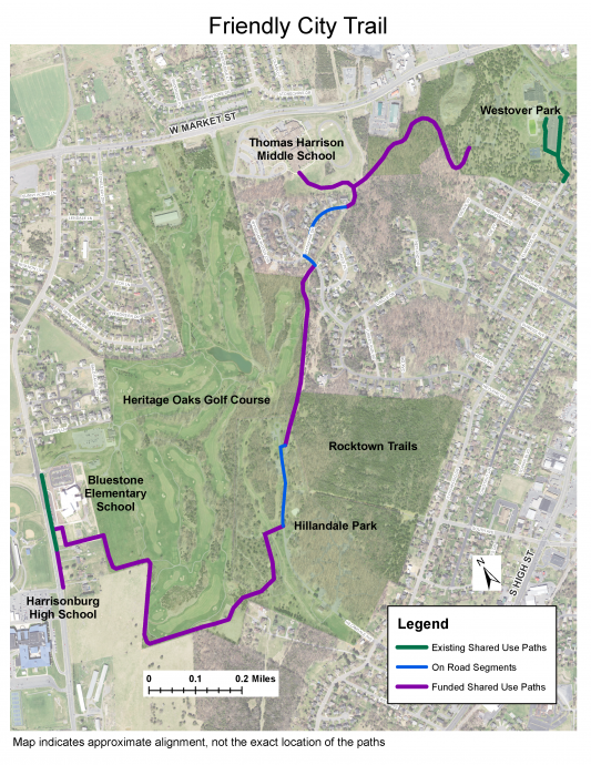
November 9, 2017 Public Meeting Materials - initial proposed alignments. Updated alignment in the map above.
Schedule:
- November 2016 – VHB under contract for engineering services
- January 2017 - Citizen Information Meeting to share concepts and receive public input
- Late 2017 – Design Public Hearing to show proposed route and receive feedback
- January 23, 2018 – Presentation to City Council; Public Hearing
- 2019-2020 – Right of way
- Fall/Winter 2020 - Path Name Suggestion Survey
- Spring 2021 – Construction
- Fall 2021 - Path Naming Survey - Vote for Finalists
- November 2021 - Friendly City Trail was chosen by City Council based on feedback from a community survey
- Winter 2021 - Anticipated completion
- May 25, 2022 - Ceremony to Mark Completion of Friendly City Trail
- Dogwood Drive Sidewalk
The project constructs a sidewalk on the west side of Dogwood Drive between the W. Market Street sidewalk and the path entrance to Westover Park. Funded through the Community Development Block Grant (CDBG) Program.

